Australia Weather News
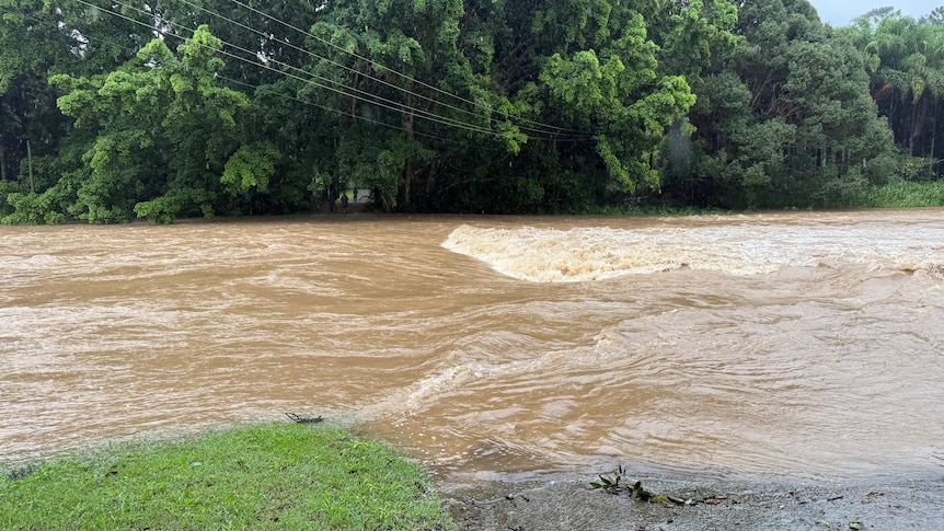
Currumbin Creek Road is now likely to flood and Currumbin Creek itself is now at 46.84 metres — nearly two metres above normal levels — and rising. March 29, 2025 (ABC Gold Coast: Mackenzie Colahan)
An emergency flood alert has been issued for the Gold Coast as the weather bureau warns eroded beaches could be lashed again.
The City of Gold Coast has told people in Currumbin Valley to take action now due to major flooding.
Currumbin Creek Road is now likely to flood and Currumbin Creek itself is now at 46.84 metres — nearly two metres above normal levels — and rising.
Homes and buildings are likely to be flooded, authorities say.
A Prepare Now alert has also been issued for Tallebudgera.
More rain expected
More rain is expected on Saturday afternoon, especially in the Currumbin and Tallebudgera catchments, and flooding could get worse quickly.
Earlier, the Bureau of Meteorology (BOM) said some parts of south-east Queensland could get between 50 and 100 millimetres of rain on Saturday, with elevated and coastal areas potentially seeing even higher totals, as the weather system that flooded the state's outback moves south.
Although well short of the rainfall totals seen just a few weeks ago with ex-Tropical Cyclone Alfred, rivers and creeks could "respond rapidly" to even moderate rain, senior forecaster Felim Hanniffy said.
"Catchments are saturated and there's very little wiggle room to absorb any further moisture," he said.
"So, a watch point will be that creek and river systems are likely to respond as well, with the potential for riverine and localised flash flooding."
In the Gold Coast hinterland, 24-hour rainfall totals have reached up to 200mm.
Strong onshore winds, hazardous surf and significant swells are predicted along the coast — potentially eroding beaches that were smashed by massive ocean swells generated by Alfred's approach.
A wet weather system currently over Hervey Bay is expected to move south on Saturday afternoon, bringing more rain to the region.
Gold Coast local disaster coordinator Mark Ryan said it could bring hazardous winds of up 55 kph and another 100mm of rain.
"We're really keen for people particularly along those Tallebudgera and Currumbin catchments to really keep an eye on it," he said.
River flood warnings
Further north, warnings are in place for the Mary River, with major flooding likely at Tiaro and minor flooding at Gympie and Maryborough in the afternoon.
The Kidd Bridge over the Mary River is underwater with the river expected to rise at least another metre by Saturday afternoon.
Gympie Mayor Glen Hartwig said there had been heavy rainfall across the Mary River catchment.
"If you're out on the road, travel with extreme care, there is a lot of localised flooding and heavy inundation in different pockets and go to the council disaster dashboard to get regular updates," he said.
Lady Elliot Island saw the wettest night in decades with almost 300mm in under 24 hours.
"At Lady Elliot we have a saying it never rains but it pours but geez, last night set some good records," island custodian Peter Gash said.
"I'm 40 years in the place and my memory's pretty good with numbers and I don't think it's come anything close."
Not including yesterday's rain, the Brisbane CBD had registered 508mm of rainfall for March — well above the month's average of 140mm.
The Gold Coast dramatically exceeded its average rainfall for March with just under 500mm registered in the seaway gauge.
On Friday Mayor Tom Tate said work to repair Gold Coast beaches would be paused until the rain eased.
"I can't have heavy equipment on sand that's soft, sodden," he said.
"It's going to cost us a couple of days."
But he said he was still "confident" beach works would be done by the Easter long weekend, renewing his promise to buy beer for everyone on the Gold Coast if he didn't meet the deadline.
ABC