Australia Weather News
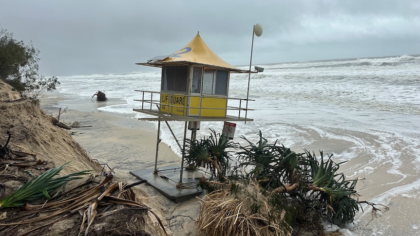
The erosion is so extensive at the Surf Life Saving tower at Philips Park, near Sea World, that it has slipped from its footings onto the sand below. (ABC News: Syan Vallance)
Authorities are warning Tropical Cyclone Alfred is gaining steam off the south eastern Queensland coast, with forecasts expecting it to approach the mainland early on Saturday morning.
The system is sitting 50 to 60 kilometres away from Moreton Bay and North Stradbroke outer islands, 70 kilometres off the Gold Coast and 85 kilometres east of Brisbane as of Friday evening.
Angus Hines, from the Bureau of Meteorology, said the outer Brisbane islands were in the firing line.
"It does look like those island regions will be the first to cop the full force of the tropical cyclone crossing," he said.
"It's only moving quite slowly but it still could cross those outer islands at around 2am local time tomorrow morning, and then it may take several hours to cross Moreton Bay and make it onto the mainland."
Mr Hines said the estimated mainland crossing time could be about 6am, depending on the cyclone's track.
"It's just a little bit faster [than originally predicted] … as we see it has picked up a bit of extra movement this evening," he said.
The Bureau of Meteorology said as Brisbane winds ramp up overnight, other parts of the east coast needed to stay vigilant around rainfall totals.
It comes as authorities continue to search for a man who was washed into floodwaters on Friday afternoon.
Emergency services said they received a call about a four-wheel drive that had been washed off a bridge and into fast-running water while driving across Wild Cattle Creek, about 23 kilometres north-east of Dorrigo.
The male driver was able to get out of the car and secure himself to a tree branch about 30 metres from the river bank, where officers from Coffs/Clarence police district were able to speak with him.
However, shortly after 3pm, the man was swept from the tree and went underneath the water, and has not been seen since.
Police and emergency services conducted a preliminary search for him and will continue with aerial assistance.
Meanwhile, they continue to respond to requests for help along the coast, contending with fallen trees, powerlines and rising floodwaters.
'Plan for the worst'
Evacuation orders stretch over dozens of communities in south-eastern Queensland and northern New South Wales with many regions bracing for the worst of the weather to hit early on Saturday morning.
As of 12am on Saturday March 8, the Bureau of Meteorology estimated the cyclone was expected to hit the Stradbroke and Moreton Bay islands about 6am on Saturday as a category one system.
It will travel over the mainland coast, most likely between Noosa and Beenleigh, as a category one between 6am to 7am.
"In this case, it is really large and slow-moving," Queensland Premier David Crisafulli said.
"Plan for the worst, and let's see what gets delivered."
[presser]The Bureau of Meteorology has warned up to 800 millimetres of rain could fall throughout the system, although the threat of storm surges has begun to ease.
Storm surges have already caused significant damage to parts of the coast, with the cyclone producing winds of up to 100 kilometres an hour.
Gold Coast locals said parts of their famous coastline had already been completely washed away.
"I'm just so shocked and amazed to see the power of the ocean and what it can do," said resident Fraser Douglass.
"The power of the ocean, I don't think any of us appreciate it until we see it," he said.
Resident Deacon Sheppard said he saw the damage get increasingly worse as he travelled from Surfer's Paradise towards Southport Spit.
"It's not what I expected," he said.
What lies ahead
Forecaster Rosa Hoff said as the cyclone passes over, it was important to keep in mind the flood threat was ongoing.
"The majority of the rainfall we're seeing on the radar is offshore of Cape of Byron, making its way toward the Gold Coast," she said.
"Once the cyclone crosses the coast, the remnants of what will then be ex-tropical cyclone Alfred will hang around across the weekend."
High tides are likely to continue causing minor flooding of coastal low-lying areas between Double Island Point and Ballina.
Gales with wind gusts up to 120kph are occurring near the coast between Cape Moreton and Yamba, and will extend inland later on Friday night.
Wind gusts up to 155kph are set to develop around the Moreton Bay islands and coastal locations on the northern Gold Coast.
Heavy to locally intense rainfall is expected to continue near and south of the system's centre during the weekend.
"A chance of significant rainfall totals, particularly on top of rainfall that has already fallen, will continue to be a risk into Monday and possibly Tuesday as well," Ms Hoff said.
Brisbane Lord Mayor Adrian Schrinner said that Saturday was "the danger zone in particular when it comes to flash flooding".
He warned some rainfalls could "potentially exceed the levels we saw in the 2022 flood".
"Even though that is not the most likely outcome, it is still a possibility that we need to be prepared for."
He also warned against people thinking the disaster preparations were an overreaction.
"We hope for it to be a fizzer, but the reality is it could be something incredibly serious," he said.
He argued that while cyclones more commonly hit northern Australia, "those areas are much more sparsely populated", with 3 million people potentially affected by Cyclone Alfred.
Authorities have supplied almost 1 million sandbags to local governments and said more were in reserve if needed after the cyclone.
Emergency warnings for northern NSW can be found here.
Emergency warnings for south-east Queensland can be found here.
Mass power outages and fallen trees
There are in excess of 100,000 homes without power across both states.
Both Energex and Essential Energy have warned customers to expect a protracted time without power, as crews wait until it's safe to begin repairs.
States shut down
Buses, trains and ferries were among public transport that stopped in the area.
Queensland Police said it had conducted a number of search and rescue missions throughout Friday — including swimmers, kayakers or jet-ski riders.
"Now is not the time to be in the surf," Queensland Police Acting Commissioner Shane Chelepy said.
Mr Crisafulli said more than 1,000 schools had been closed on Friday.
Plans for openings or closures on Monday would be announced on Sunday, he said.
Across the border, over 300 schools in northern NSW will remain closed on Monday.
Hospitals remain open for emergencies, but all elective surgery has been cancelled.
Extra help
The Australian Defence Force has also been called in to support the regions, said Prime Minister Anthony Albanese.
"They will support the SES with road clearance, sandbagging, clearing access to critical infrastructure, damage assessments and essential services," he said.
NSW Premier Chris Minns said the next 48 hours would be difficult for communities who were still recovering from the trauma of the 2022 floods.
"Our sincere hope is that the community gets through this without any loss of life and that we can, when this is all over, focus on the rebuild," Mr Minns said.
The federal government also announced joint funding agreements with NSW and Queensland governments for $15 million in each state to help in clean-up and recovery work.
ABC