Australia Weather News
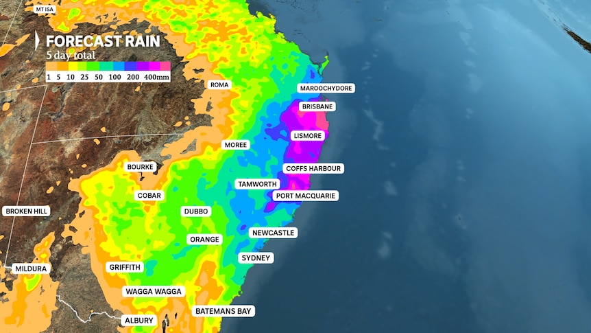
An average total of near 500mm is likely near the Queensland/NSW border this week. However, localised totals could come close to 1,000mm. (ABC News: Tom Saunders)
Tropical Cyclone Alfred is now nearing the coastline and severe weather is gradually increasing, however, the most intense rain will not arrive until the weekend for many regions.
The delayed onset of the most intense conditions is thanks to Alfred's erratic and slow path, which is likely to continue even after landfall, resulting in a prolonged period of flooding rain for another 48 hours across south-east Queensland and north-east New South Wales.
However, Alfred's influence will also spread well inland and south this weekend, with even Sydney likely to see a deluge by early next week.
Here is an updated guide on Tropical Cyclone Alfred's future movements, and a day-by-day outline of the weather and impacts to expect on the ground as the cyclone tracks west onto the coast and eventually over the eastern inland.
Friday
Alfred's position and strength — a slow and possible erratic track west towards the southern Queensland coast with possible landfall at night.
During the past 48 hours, Alfred has pounded the coast with wind gusts above 90 kilometres per hour and huge waves in excess of 10 metres.
As Alfred approaches the coast, the intensity of wind and surf will reach a maximum, especially near the core where wind gusts could peak at close to 150 kilometres per hour — that's strong enough to cause roof damage, decimate crops and bring down large trees.
Thankfully, the destructive gusts are likely to be confined to a small region within a 150km radius south from the eye.
[link — tracker]Further north and south, damaging gusts from 90 to 124kmh should continue to about Grafton and the Sunshine Coast.
Rainfall is also increasing, and parts of the NSW coast and Gold Coast have already received hundreds of millimetres, well before the heaviest deluge even arrives.
Totals should start to peak later Friday, including six-hour totals up to 250mm, most likely just to the south of the eye around the Gold Coast and Northern Rivers, although a slight error in the track to the north could also lead to very intense rain over Brisbane.
That's enough rain to trigger life-threatening flash flooding, while major river flooding should also commence with 24-hour totals up to 450mm near the border.
Torrential falls are also likely across the Mid North Coast today, resulting in a flood threat down to the Manning River, which runs through Taree.
As Alfred moves west, the rain will may also spread to the NSW northern ranges and southern Darling Downs with well over 50mm possible as far west as Stanthorpe Glen Innes and Armidale.
Damaging surf and coastal erosion will persist, and coastal flooding from high tides will be significant if landfall coincides with high tide.
Saturday
Alfred's position and strength — if the cyclone's movement remains erratic, landfall may not occur until early Saturday.
Winds and therefore seas and swells could still peak very early Saturday in some regions near the eye of the storm, however, once Alfred moves inland conditions will start to abate.
The threat of heavy rain from decaying cyclones can last for days if a system remains slow moving, and Saturday will produce the heaviest totals in many regions.
Modelling shows rain accumulations on Saturday of at least 100mm are possible from Brisbane to the NSW Mid North Coast.
In a repeat of Friday, dangerous six-hour totals may reach 250mm and 24-hour totals may hit close to 450mm — especially around the Gold Coast and Northern Rivers.
Brisbane could also lie in the rain bullseye on Saturday, a scenario that would lead to widespread flooding across the city.
Heavy falls will also continue on the adjacent ranges, and 48 hour totals could now exceed 100mm for much of the Darling Down and Northern Tablelands
The ongoing heavy rain across already flooded regions will exacerbate river levels in many areas.
Sunday
Alfred's position and strength — on Sunday, the remnants of the cyclone are likely to be tracking from southern Queensland into NSW.
Days after a cyclone is declassified, they often still generate heavy rain, and Alfred's slow path should maintain torrential totals on Sunday across south-east Queensland and north-east NSW.
Sunday's totals may even exceed 200mm in some areas that are already experiencing major flooding, and event totals will now be well over 500mm or even near 1 metre for localised pockets.
Rain and thunderstorms will also spread south through western and central NSW with pockets of flash flooding possible.
Monday
Alfred's position and strength — the remnants of the cyclone are likely to track from inland NSW towards the coast.
An accelerated path south on Monday should finally allow rain to ease over Queensland and northern NSW, although river levels will still be peaking in many areas for several days.
Widespread rain should continue falling over central east NSW, including Sydney, where some suburbs could receive close to 100mm.
ABC