Australia Weather News
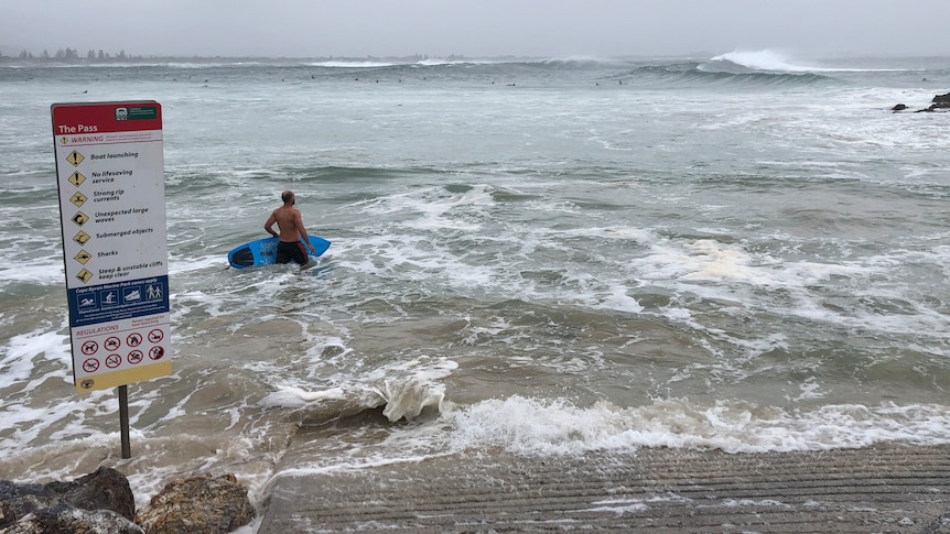
It's expected that Cyclone Alfred will result in waves as high as 8 metres along the northern NSW coast. (ABC News: Bruce Mackenzie)
Residents in northern New South Wales have been told to stay indoors as the region awaits the arrival of Tropical Cyclone Alfred.
The Bureau of Meterology (BOM) on Wednesday afternoon issued flood warnings for NSW's Northern Rivers.
According to the BOM, major flooding is possible along the Bellinger River at Thora from Friday afternoon, with a potential rise of 5.8 metres.
The forecast has also spurred a warning of major flooding for Bellingen on Saturday, where the Bellinger River is tipped for a possible rise of 8.2m.
Rainfall started increasing in intensity from Wednesday throughout northern NSW and south-east Queensland.
Parts of the northern NSW coast have already experienced rain squalls and south-easterly winds, with forecasts predicting 6m ocean swells.
The NSW State Emergency Service (NSW SES) has advised those residing in a number of Northern Rivers towns near the Queensland border — including Tweed Heads, Ballina and Lismore -—to now stay indoors, unless directions to evacuate have already been given.
Ahead of the worst of the weather, the NSW education department confirmed more than 200 schools from the Clarence Valley north to the Queensland border, and inland to the Kyogle Shire would be non-operational from today till at least Friday.
NSW TAFE campuses, pre-schools and Ballina Airport have closed.
The NSW SES said the Northern Rivers region was experiencing a major shortage of sandbags.
Murwillumbah SES has already gone through 3,000 bags today and is expected to run out for the second time in the next few hours.
NSW Premier Chris Minns, who will be staying in the region over the next few days, said resources were being shared across the border and a large contingent of emergency services resources are already in place across the Northern Rivers.
"We need to bunker down over the next 48 hours and get through what may be a very difficult time," he said.
People in an area vulnerable to flooding have been told to relocate well before Thursday afternoon and 12 evacuation centres will begin opening across the Northern Rivers this afternoon from 4pm.
The premier said people needed to be prepared by downloading the Hazards Near Me app, listen to emergency broadcasts and not drive or walk through floodwaters.
People in the region are encouraged to buy enough basic provisions for a few days but avoid panic buying ahead of the cyclone's arrival.
Mr Minns said major supermarkets had contingency plans in place should a community become isolated by flooding.
NSW in vulnerable position
The position of NSW in relation to the weather system puts it in a vulnerable position.
NSW is in the forward left quadrant, which is the most dangerous side of a tropical cyclone.
[link — tracker]Air spins clockwise around a low pressure system in the southern hemisphere, so the wind direction to the south of Alfred is moving in the same direction as the cyclone, combining their speeds to cause more damage on the poleward side.
Destructive wind gusts of up to 155 kilometres per hour may develop about the exposed coastal and island locations near and to the south of the track, as Alfred's destructive core approaches and crosses the coast.
These wind gusts could uproot trees and damage rooves.
Six-hourly rainfall totals between 200 and 250 millimetres and 24-hour totals between 300 and 400mm are also possible on the southern side of the system.
This level of rainfall could lead to dangerous flash flooding, but there is also a high risk of riverine flooding in all major catchments of the NSW north coast, from the Tweed River to the Hastings River.
BOM's manager of decision support services Jane Golding said the weather system was likely to bring "very heavy rainfall over extensive areas with the potential to cause extensive flooding" and a flood watch is in place for moderate to major flooding from the Queensland border down to, but not including, the Manning River.
"The key message is that we can expect from this system along with destructive wind and extensive flooding most likely major flooding, as well as the potential for some dangerous and life-threatening flash flooding," she said.
"So the rainfall is expected to increase today furthering tomorrow but peak along with the wind on Thursday night/Friday morning as the system approaches the coast."
Unfamiliar territory
NSW SES Commissioner Michael Wassing said most NSW residents were not familiar with cyclones.
The last cyclone to cross Queensland's south-east was Zoe in 1974, while Nancy came close to NSW in 1990.
"We are dealing with three natural disasters in one," Mr Wassing said.
Mr Wassing said a significant coastal surge was expected to push water half a metre above the usual high tide mark.
"If you live directly on the coast and you do not feel safe in that situation, now is the time to relocate," he said.
Cyclone resulting in big surf
The cyclone is expected to make landfall almost exactly three years after rapidly rising flood waters devastated Lismore and other communities in the Northern Rivers.
Residents have acted early to secure sandbags and test backup communication systems ahead of the wild weather.
Ms Golding said the BOM had issued a hazardous surf warning for the entire NSW coast, with low-lying areas north of Port Macquarie at risk of coastal erosion.
There have been reports of gale force winds at Byron Bay this morning and Ms Golding said winds are set to strengthen over the coming days.
Residents in the area are preparing with sandbags and stocking up on supplies, clearing out supermarket shelves to ensure they have enough essentials.
Have you been affected by Cyclone Alfred? We want to hear your storyABC