Australia Weather News
Alfred’s centre should be just off the southern Queensland coast at 12pm Thursday with rain and winds increasing on the coast. (ABC News: Tom Saunders)
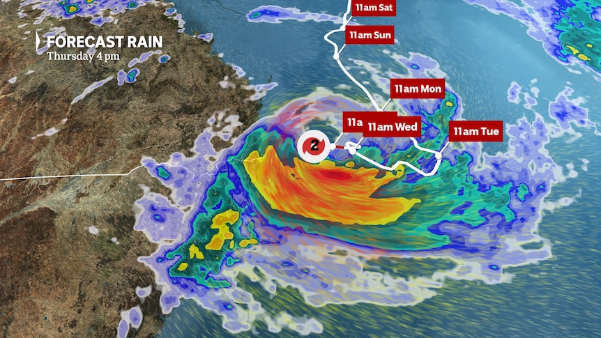
Tropical Cyclone Alfred is destined to become one of the most significant weather events in Australia's recent history, bringing a multitude of severe weather across several days.
Already this week, as Alfred gathered steam offshore, it has pounded the coast with waves in excess of 12 metres, and has soaked parts of the Gold Coast, Northern Rivers and Mid North Coast with well over 100 millimetres of rain.
As of 11am Thursday, Alfred was still more than 200 kilometres offshore and moving slowly at less than 10 kilometres per hour.
Alfred's strength remained as a category two tropical cyclone, which is defined as a storm with winds around the eye gusting between 125kph and 164kph.
Here is an updated guide on Tropical Cyclone Alfred's future movement and a day-by-day outline of the weather and impacts to expect on the ground as the cyclone tracks west onto the coast and eventually over the eastern inland.
Thursday
Alfred's position and strength — a slow track west towards the southern Queensland coast as a category two cyclone.
The gradual increase in winds and rain experienced on Wednesday will continue along the northern NSW and southern Queensland coast today.
Gales are likely from about Grafton and Double Island Point, meaning gusts over 90kph, while closer to the Queensland/NSW border, including parts of Brisbane, gusts could hit 120kph along exposed parts of the coast later as Alfred nears the coast.
Winds of this strength can topple trees and even cause minor house damage.
Rain is becoming slowly heavier — however torrential falls are no longer likely until tonight due to Alfred's delayed arrival.
The heaviest falls remain in the region south of the centre where the winds are onshore, with the Mid North Coast already receiving a soaking while the Sunshine Coast is only seeing the odd shower.
Twenty-four-hour totals could exceed 100mm in pockets of the Gold Coast, Northern Rivers and inland Mid North Coast, although flash flooding is no longer likely until overnight.
Alfred's wide field of offshore gales will also maintain huge waves, with maximum heights well above 10 metres on both sides of the border.
When combined, high tides will lead to ongoing beach erosion and coastal inundation.
Friday
Alfred's position and strength — a slow track west onto the far southern Queensland coast as a category two cyclone.
As Alfred approaches the coast and possibly makes landfall, the intensity of most impacts will reach a maximum.
Critically, the most dangerous side of Alfred is to the south where winds are easterly — the same direction as the storm movement which compounds speeds.
When the core crosses the coast, wind gusts could peak at close to 150kph — that's strong enough to cause roof damage, decimate crops, and bring down large trees.
Thankfully, the destructive gusts are likely to be confined to a small region within a 150km radius south from the eye.
Further north and south, damaging gusts from 90 to 124kmh should continue to about Grafton and the Sunshine Coast.
Rainfall should also start to peak on Friday, although many regions will now receive heavier rain on Saturday, including six-hour totals up to 250mm, again most likely just to the south of the eye around the Gold Coast and Northern Rivers.
That's enough rain to trigger life-threatening flash flooding, while major river flooding should also commence with 24-hour totals up to 400mm near the border.
For the Mid North Coast, hundreds of millimetres is likely on Friday, resulting in a flood threat down to the Manning River that runs through Taree.
As Alfred moves west, the rain will may also spread to the NSW northern ranges and southern Darling Downs with well over 50mm possible as far west as Stanthorpe, Glen Innes, and Armidale
Damaging surf and coastal erosion will persist, and coastal flooding from high tides will be significant if landfall coincides with high tide.
Saturday
Alfred's position and strength — if Alfred's movement remains erratic, landfall may not occur until Saturday, which will prolong the duration of severe weather.
Winds and therefore seas and swells could still peak on Saturday in some regions near the eye of the storm.
Once Alfred moves inland, conditions will start to abate.
However, the threat of heavy rain from decaying cyclones can last for days if a system remains slow moving, and Saturday will produce the heaviest totals in many regions.
Modelling shows rain accumulations on Saturday of at least 100mm are still possible from Brisbane to the NSW Mid North Coast, and like Friday, localised six-hour totals may exceed 200mm and 24-hour totals may hit close to 400mm — especially around the Gold Coast and Northern Rivers, but possibly Brisbane if a more northern track is taken.
Heavy falls will also continue on the adjacent ranges, and 48-hour totals could now exceed 100mm for much of the Darling Down and Northern Tablelands
The ongoing heavy rain across already flooded regions will exacerbate river levels in many areas.
Sunday
Alfred's position and strength — on Sunday Alfred is likely to be tracking south over inland NSW as a decaying low but this track may be delayed.
Days after a cyclone is declassified, they can still bring heavy rain and an accelerated path south on Sunday will spread widespread rain through NSW and the ACT, including Sydney and Canberra.
While a track south is good news for south-east Queensland and north-east NSW, unfortunately, some modelling shows Alfred stalling, a worst-case scenario that would lead to further heavy rain over already flooded catchments.
Modelling now also shows Alfred may re-appear off the NSW southern coast on Monday as a mid latitude low.
Have you been affected by Cyclone Alfred? We want to hear your storyABC