Australia Weather News
Torrential rain and wild winds are coming for northern NSW. (ABC News: Floss Adams)
Northern New South Wales could bear the brunt of the torrential rain and wild winds accompanying Tropical Cyclone Alfred, which is expected to hit the coast in the coming days.
The category two cyclone is expected to make landfall near Brisbane on either Thursday night or Friday morning.
Rainfall is expected to start increasing in intensity from Wednesday throughout northern NSW and south-east Queensland.
However, the position of NSW in relation to the weather system puts it in a vulnerable position.
NSW is in the forward left quadrant, which is the most dangerous side of a tropical cyclone.
[link — tracker]Air spins clockwise around a low pressure system in the southern hemisphere, so the wind direction to the south of Alfred is moving in the same direction as the cyclone, combining their speeds to cause more damage on the poleward side.
Destructive wind gusts of up to 155 kilometres per hour may develop about the exposed coastal and island locations near and to the south of the track, as Alfred's destructive core approaches and crosses the coast.
These wind gusts could uproot trees and damage rooves.
Six-hourly rainfall totals between 200 and 250 millimetres and 24-hour totals between 300 and 400mm are also possible on the southern side of the system.
This level of rainfall could lead to dangerous flash flooding, but there is also a high risk of riverine flooding in all major catchments of the NSW north coast, from the Tweed River to the Hastings River.
Cyclone resulting in big surf
The cyclone is expected to make landfall almost exactly three years after rapidly rising flood waters devastated Lismore and other communities in the Northern Rivers.
Residents have acted early to secure sandbags and test backup communication systems ahead of the wild weather.
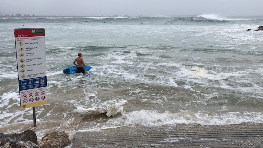
The Bureau of Meteorology (BOM) has issued a hazardous surf warning for the entire NSW coast, with low lying areas north of Port Macquarie at risk of coastal erosion.
"We are already seeing waves in excess of four metres, we are likely to see them pushing up to five, six, seven metres over the coming days," said BOM senior forecaster Miriam Bradbury.
"Around the time of crossing those wave heights may push up to eight or nine metres."
Flood alerts issued
The NSW SES North Eastern Zone issued a series of flood alerts on Tuesday afternoon for northern parts of the state.
Coraki, Woodburn, Swan Bay, Casino, Tweed Coastal Creeks and the Lismore Upper Catchment were told to "stay informed" on the evolving weather event, with the Richmond River predicted to experience moderate to major flooding.
NSW SES also said it was facilitating over 20 community meetings in impacted towns to ensure residents had up-to-date information.
At the Northern NSW SES community event on Tuesday night, SES incident commander Joanna Jones asked Northern Rivers residents to stay informed.
"We are committed to keeping the community safe through good information," she said.
"This rainfall will intensify as Alfred gets closer to the coast. The rainfall could lead to dangerous and life-threatening flash flooding.
"If your property has loose items, please take the time before the storm starts, to put them away. They might not cause harm to you, but they could cause harm to somebody else."
NSW SES Assistant Commissioner Nicole Hogan urged the community to remain calm and support each other.
"This is an unpredictable, multi-hazard weather event and residents in the Mid North Coast and Northern Rivers need to prepare for damaging and destructive winds and heavy rainfall which can cause flooding," she said.
"If your community becomes isolated and needs resupply of essential goods, NSW SES will assist with this."
ABC